Richard Rogers

A sculpt of one of the pieces from Paolozzi’s gallery (From Edinburgh way back in October) using the very useful p3d web OBJ viewer now features on my website. I’m working to get the texture overlayed for a better viewing experience, and thinking a lot about the various ways you could go about the surface reconstruction to save time/memory for preparation of photoscans for wider distribution. See it on p3d here.

With this in mind I’ve got an idea to work towards a zoomable interactive 3D viewer of say, for example, the erosion of a coastal cliff using blend4web to animate it – something to keep in mind in the future!

My website

James

COSI-Corr

Since reading a paper from last year by Arko Lucieer (Who’s quickly becoming one of my favorite scientists) detailing the evolution of a landslide in South East Tasmania, I’ve been introduced to COSI-Corr, a package distributed by Caltech which is used for quantifying ground deformation based on multi-temporal imagery.

Watch this space for details on how I plan to integrate it into a structure-from-motion workflow, as I think it will be very useful for automatic monitoring of deformation using photogrammetry, as is the topic of Polpreecha Chidburee‘s PhD which seeks to develop such a tool!

Can we use Remote Sensing to find mass graves?

An interesting idea was put forward during a talk a the RSPSoc’s student conference I attended last week, searching satellite signals for indications of mass graves by a researcher at Bournemouth University, Emily Norton.

The idea is based around the detection of the classic vegetation health indicator, NDVI, and inferring from that signal the likelihood a grave is present. As a control the researchers dug a grave filled with pig carcasses which seemed to show a reasonably clear signal. It’s clearly quite ambitious using 1 datastream to try to distill out the grave signal, and so it’s used as a basic indicator of initial search sites.

Given InSAR is so acute for changes in topography, and considering it’s already been well developed to detect changes in microtopography (for instance land-mine detection, just 1 of many examples, albeit not at the same scale), I wonder how big a grave would have to be to show up in an InSAR scene, or if the combination of spectral indices with RADAR would produce a better indication of their presence.

It was a very interesting talk on an important topic, I’ll be keeping up with her research in the future!

Auto-Landsat

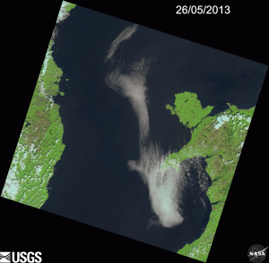
Having returned from the wonderful wavelength conference which I now recommend be part of any remote sensing students calendar, I realized how much I had been missing looking at satellite images, and how little I’ve engaged with Landsat8 in general. Thus, I spent today writing a python scraper that pulls the RGB previews of each Landsat8 scene given a GPS coordinate input and spits out an animated gif of the tiles covering that region.

Naturally I started with Dublin, with some pretty hilarious results due to the massive amount of cloud cover! I’m looking forward to pulling out some gifs of other areas, I’ll take requests on it too if anyone reading this would like one of a specific region. The georeference is off I’m aware, but I unfortunately don’t have enough time to sink in to solve that issue, check out the results in HD on my webpage here!

James

LC82050232013146LGN00